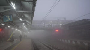
North India may see dense fog through January 4, which will impact train and aviation operations.
The India Meteorological Department (IMD) reported that moderate to intense fog was still covering regions of North India on Sunday morning, including Delhi, Haryana, and Uttar Pradesh. No break is predicted until January 4, 2024.
Jammu (Jammu and Kashmir), Pathankot and Bathinda (Punjab), Jorhat (Assam), and Agra (Uttar Pradesh) all reported having zero visibility.
According to the weather department, visibility was 25 meters in Ambala, Haryana; 50 meters in Bikaner, Rajasthan; Patiala, Punjab; Chandigarh, Gwalior, Madhya Pradesh; and 200 meters in Amritsar, Punjab; and Hisar, Haryana.
Numerous trains were running late because of poor visibility during North India’s coldwave.
Visibility at Delhi’s Indira Gandhi International Airport was eight hundred meters.
Hazy conditions to start with
According to the IMD, from December 31 (Sunday) to January 4 (Thursday), extremely dense fog conditions (visibility 550 meters) were highly likely to dominate over several portions of Punjab during the late evening to morning hours and across West Uttar Pradesh during the midnight and morning hours.
From December 31 (Sunday) to January 4 (Thursday), severe fog conditions (visibility 50-200 meters) may be experienced in Uttarakhand, the IMD reports.
On Sunday, December 31 and Monday, January 1, same conditions were expected over north Madhya Pradesh, north Rajasthan, and Jharkhand; on Monday, December 31, similar conditions were expected over Gangetic West Bengal; and on Monday, December 31, to Tuesday, January 2, there were similar conditions expected over Odisha, Bihar, Assam, Meghalaya, Mizoram, and Tripura.
Additionally, according to the Met Department, there was a good chance of chilly days in some areas of Punjab, Haryana, isolated areas of Uttar Pradesh, Madhya Pradesh, and north Rajasthan until Sunday, December 31.
Over the next two days, there was anticipated to be a drop in maximum temperatures of two to three degrees Celsius over various areas of Central and Northwest India; the remaining portions of the country might not see any notable changes in minimum temperatures.
SNOWFALL AND RAINFALL FORECAST
On Sunday, December 31, there was a slight chance of light, isolated rainfall or snowfall over Jammu & Kashmir, Ladakh, Gilgit-Baltistan, Muzaffarabad, Himachal Pradesh, and Uttarakhand due to a weak western disturbance.
Because of lower-level easterly winds from the Bay of Bengal, light isolated rainfall was anticipated throughout Uttar Pradesh, Madhya Pradesh, and Chhattisgarh from January 1-3, according to the IMD.
According to the weather service, there could be mild to moderate rainfall in certain areas of south Tamil Nadu, south Kerala, and south Lakshadweep until Wednesday, January 3.


